What is the “Carte du Ciel” project?
The project “Carte du Ciel” (lit. Map of the Sky) is one of the very first large international astronomical projects. Launched in Paris in 1887, it would include 18 observatories from all over the globe. Its goal was extremely ambitious: to carry out a photographic map of the entire celestial sphere at the beginning of the XXth century in order to pass on precise and objective sky maps to the astronomers of the next generations. It would enable them to compare the maps with the sky of their epoch and to observe changes in the positions or in the luminosities of the stars recorded. Each frame would encompass 4 square (sq.) degrees. Since the celestial sphere measures approximately 41.200 sq. degrees and some overlap is needed in order to avoid errors, a total of 20.600 frames would be needed. Moreover, each frame would be exposed 3 times and each exposure would last 30 minutes, which leads to a total of 30.900 hours of work for the data acquisition only. Each observatory would be assigned its own region of the sky to map, while the observing protocol would be identical in all observatories to ensure consistent results. For that purpose, each participant would build a specific telescope following the model of the Parisian astrophotograph. All frames would be taken on glass plates of 16 cm x 16 cm, enlarged twice, then copied by rotogravure unto copper plates before being printed on paper. This Herculean task took more than 80 years before being interrupted even though unfinished in 1970 because of new developments and technical innovation.
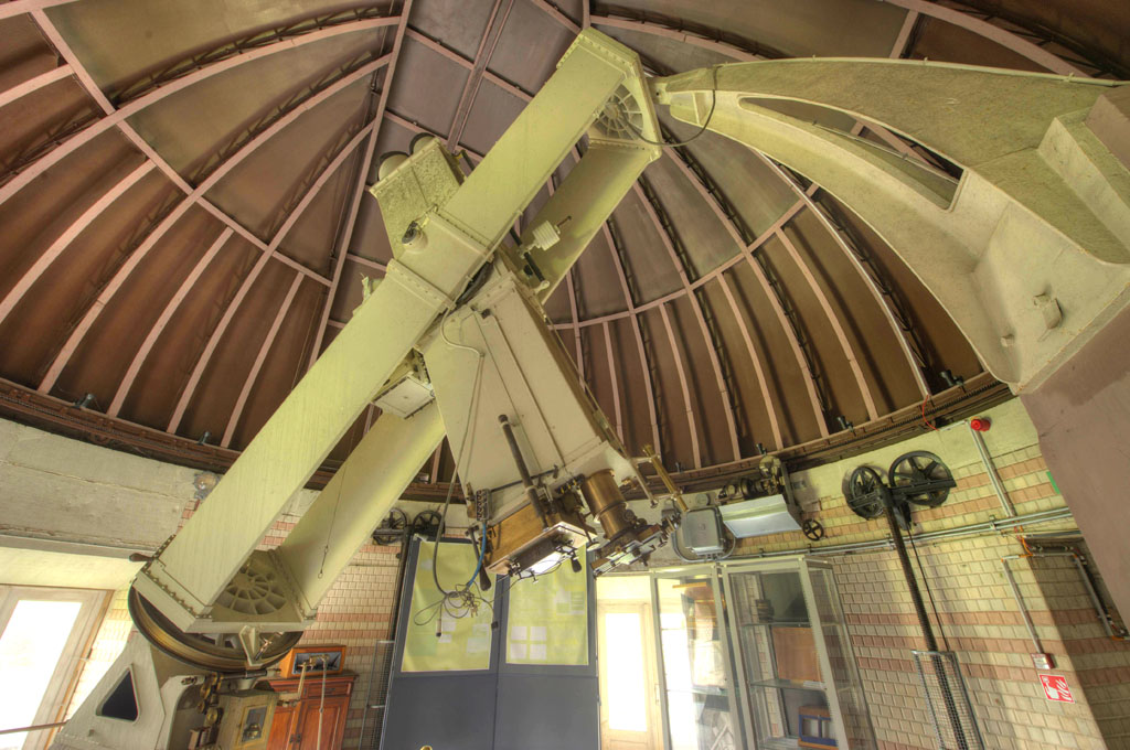 original astrograph in its actual state, located in the annex building nick-named “Carte du Ciel”, built in 1907, when the observatory of Ukkel officially replaced that of Potsdam for the realisation of the Carte du Ciel.
History and ROB’s contribution
It all starts with the successful application of photography to astronomy: the brothers Henry from the Observatory of Paris are among the first people to shoot high-quality photographs of (even faint) stars. The director of the Observatory, Admiral Mouchez, shows a great interest for this new method and decides to build an astrophotograph in 1885. Meanwhile, halfway around the world, Dr. David Gill, the director of the Cape of Good Hope Observatory (British Empire), is also getting involved in astrophotography. He suggests to Mouchez to organize an international congress. François Folie, director of the Royal Observatory of Belgium, will attend the first meeting in 1887 but Belgium won’t take part in the initial project. It is only in 1904 that his successor, Georges Lecointe, will officially propose the participation of Brussels. After some delays, the astrophotograph of the “Service de la Carte du Ciel” will become operational in 1908 and despite two world wars, funding issues, and the weather, the Royal Observatory of Belgium will acquire 1232 frames until 1964. Today, the original glass plates, rotogravures and prints are preciously kept in the archive under good conditions and a project of accurate digitization is currently under way.
The legacy of the Carte du Ciel
The project of the Carte du Ciel was never entirely finished for various reasons: political and financial ones, but mostly because its duration had been largely underestimated. Belgium had planned a maximum of 20 years of work however its contribution will last nearly 60 years! This was not the case of all observatories: many will abandon their task in the course of the project. Nevertheless, the legacy of the Carte du Ciel is impressive: this first international organization will namely lead to the creation of the International Astronomical Union (IAU) in 1919 while IAU Commission 23 will be in charge of the completion of the Carte du Ciel until 1970.
The data collected in the framework of the Carte du Ciel were used in several modern scientific projects including the Tycho-2 catalogue of the Hipparcos mission: ancient stellar positions enabled the astronomers to refine the computations of the stellar proper motions measured by the satellite. But most of the data from the Carte du Ciel plates aren’t available yet in machine-readable formats and their usage is still rare. That’s why the researchers of the Royal Observatory of Belgium set up a digitization project: thanks to a unique custom-built machine, the Carte du Ciel’s photographs will soon be scanned in a resolution never reached before. This will enable the scientists to exploit this huge amount of data and maybe lead to some new discoveries.
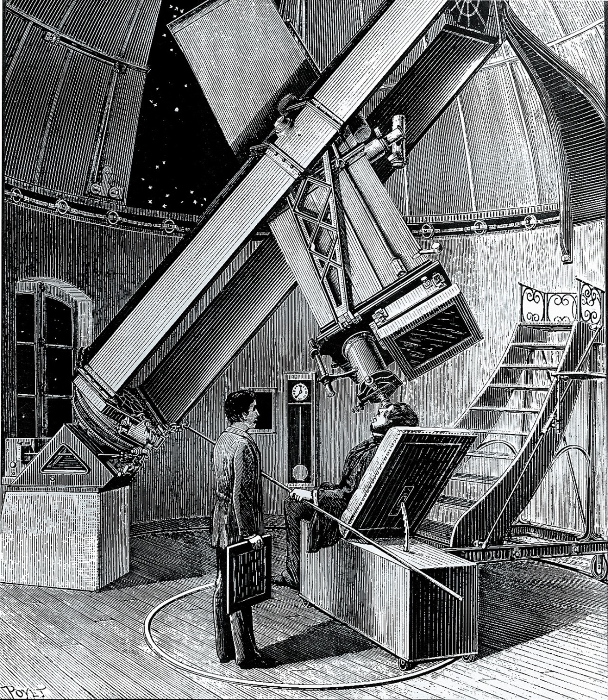
left image : Engraving of the Parisian astrophotograph illustrating astronomers at work. The telescope consists in a photographic objective of 33cm of diameter and a focal distance of 3m43 fixed to a second visual objective of 25cm of diameter and 3m60 of focal distance used to track the stars during the 30 minutes of exposure.
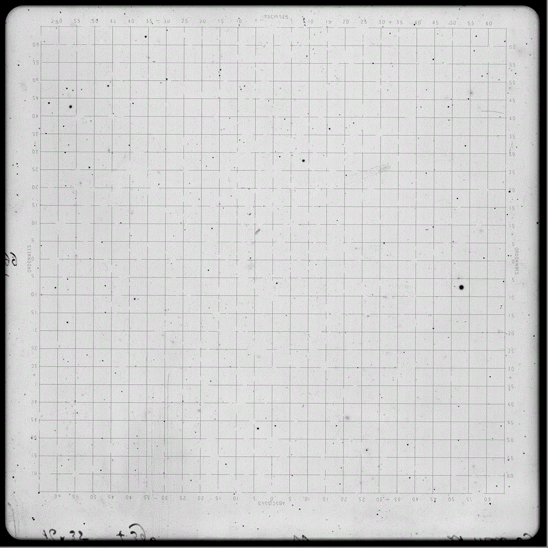
right image : Original picture from the Carte du Ciel taken at Uccle: Each star is represented by 3 points placed on the edges of a small equilateral triangle of 18/100 mm side length (1 point per exposure, the plate being slightly moved between each exposure).
Qu’est-ce que le projet de la Carte du Ciel ?
Il s’agit d’un des premiers projets internationaux astronomiques. Lancé à Paris en 1887, il regroupera 18 observatoires à travers le globe. Le but est extrêmement ambitieux : réaliser une carte photographique de l’entièreté du ciel au début du XXème siècle afin de léguer des documents précis et objectifs aux astronomes des siècles à venir. Ceux-ci pourront alors comparer ces cartes avec le ciel de leur époque et observer les changements de position ou de luminosité des étoiles. Chaque cliché couvrira une zone de 4 degrés carrés, or la sphère céleste mesure environ 41 200 degrés carrés et il faut que les clichés se superposent pour éviter toute forme d’erreur : il faudra donc en prendre 20 600. Mais ce n’est pas tout : le temps de pose pour de tels clichés sera de 30 minutes et chaque pose sera effectuée 3 fois, soit 30 900 heures rien que pour les photographies ! Chaque observatoire se verra attribué sa propre bande du ciel à cartographier mais les protocoles expérimentaux devront être strictement identiques afin d’obtenir des résultats cohérents. Chaque participant fera donc construire un télescope spécial pour le projet calqué sur le modèle de celui de Paris. Les clichés seront pris sur des plaques en verre de 16cm de côté puis agrandis deux fois et copiés par héliogravure sur des plaques de cuivre avant d’être tirés sur papier. Ce travail titanesque durera plus de 80 ans et sera arrêté en 1970 bien qu’inachevé car le développement de nouvelles technologies l’aura rendu obsolète.
Astrographe original à l’état actuel, situé dans le bâtiment annexe dit « Carte du Ciel », construit en 1907, lorsque Uccle remplaça officiellement Potsdam pour la réalisation de la Carte du Ciel.
Histoire et participation de l’ORB
Tout commence avec l’adaptation de la photographie à l’astronomie : les frères Henry de l’observatoire de Paris font partie des premiers à obtenir des clichés d’étoiles de bonne qualité. Le directeur de l’observatoire, l’Amiral Mouchez, montre un vif intérêt pour ce nouveau procédé et fait construire un astrographe en 1885. Pendant ce temps, à l’autre bout du monde, le directeur du Cap de Bonne-Espérance (Empire britannique), David Gill, se lance également dans l’astrophotographie. C’est lui qui proposera à l’amiral d’organiser un grand congrès international en avril 1887. François Folie, directeur de l’Observatoire Royal de Belgique, sera présent lors de cette première réunion mais, dans un premier temps, la Belgique ne contribueera pas au projet. Ce n’est qu’en 1904 que son successeur, Georges Lecointe, proposera la participation officielle de Bruxelles. Après quelques retards, l’astrographe de la Carte du Ciel sera mis en service en 1908. Malgré les 2 guerres mondiales, les problèmes de financement et la météo, l’Observatoire Royal de Belgique effectuera 1232 clichés jusqu’en 1964. Aujourd’hui, les clichés originaux, les héliogravures et les tirages papier sont précieusement conservés dans les archives et un projet de numérisation des données est en cours.
Héritage de la Carte du Ciel
Le projet de la Carte du Ciel n’a jamais abouti pour de nombreuses raisons : politiques, financières, mais surtout car sa durée a été largement sous-estimée : la Belgique avait compté une participation d’une durée maximum de 20 ans mais elle contribuera finalement pendant près de 60 ans ! Ce n’est pas le cas de tous les observatoires : beaucoup abandonneront leurs tâches en cours. Néanmoins l’héritage du projet de la Carte du Ciel est impressionnant : cette première organisation internationale mènera à la formation de l’Union Astronomique Internationale (UAI) en 1919 ; dont la commission 23 qui sera chargée de la réalisation de la Carte du Ciel jusqu’en 1970.
Les données récoltées pour la Carte du Ciel ont été utilisées dans plusieurs projets scientifiques dont le catalogue Tycho-2 de la mission Hipparcos : les anciennes positions des étoiles ont permis d’affiner le calcul des mouvements propres des étoiles mesurés par le satellite. Mais la majeure partie des données n’a pas encore été informatisée dans un format facilement exploitable, et son utilisation reste encore rare. C’est pourquoi les chercheurs de l’Observatoire Royal de Belgique ont monté un projet de digitalisation : grâce à une machine unique construite sur mesure, les clichés de la Carte du Ciel seront bientôt numérisés avec une résolution jamais atteinte. Cela permettra enfin d’exploiter les immenses ressources de la Carte du Ciel et aboutira peut-être à de nouvelles découvertes.
à gauche : Gravure de l’astrographe de Paris illustrant les astronomes au travail. Il comprend un objectif photographique de 33 cm de diamètre et 3m 43 de distance focale solidaire avec un objectif visuel de 25 cm de diamètre et 3m 60 de distance focale servant à suivre le mouvement des étoiles pendant les 30 minutes de pose.
à droite : Cliché photographique original de la Carte du Ciel pris à Uccle : chaque étoile est représentée par trois points disposés selon un petit triangle équilatéral de 18/100 mm de côté (1 point par pose, la plaque étant légèrement déplacée entre chaque pose).
Wat is het project van de ”Hemelkaart" (Carte du Ciel) ?
Het betreft één van de eerste grote internationale projecten op het domein van de sterrenkunde. Gestart te Parijs in 1887, zal dit project een 18-tal sterrenwachten verspreid over de hele wereld laten samenwerken. Het doel is zeer ambitieus: een sterrenkundige kaart van de volledige hemel bij het begin van de XXste eeuw opstellen om zodoende nauwkeurige en objectieve documenten achter te laten voor de astronomen van de komende generaties. Deze zullen de kaarten kunnen vergelijken met de hemelopnames van hun tijd om de veranderingen in positie en helderheid van sterren waar te nemen. Elke plaat zal een gebied van 4 vierkante graden aan de hemel weergeven. Daar de hemelbol ongeveer 41.200 vierkante graden beslaat, en er ook overlappingen tussen de gebieden voorzien zijn, zullen er 20.600 platen moeten genomen worden. Dit is niet alles: de belichtingstijd zal telkens 30 min bedragen, en elke plaat zal tot driemaal toe belicht worden, zodat er in totaal 30.900 uren nodig zullen zijn alleen al voor het platenarchief. Elke sterrenwacht zal een eigen zone van de hemel fotograferen, terwijl de experimentele procedures overal identiek zullen moeten zijn wil men coherente resultaten bekomen. Elke deelnemende sterrenwacht zal daarom over een speciaal ontworpen telescoop kunnen beschikken naar het model van dat van Parijs. De platen zullen van glas gemaakt worden, met een zijde van 16 cm, daarna worden ze 2x vergroot en via de techniek van etsing tot kopergravures omgevormd, om dan overgezet te worden op papier. Dit titanenwerk zal meer dan 80 jaar duren, en zal uiteindelijk in 1970 stopgezet worden, hoewel het nog niet helemaal afgewerkt was.
Originele astrograaf zoals hij heden te zien is in het gebouw bijgenaamd “Hemelkaart”, opgericht in 1907, toen de sterrenwacht van Ukkel officieel deze van Potsdam verving voor de realisatie van de Hemelkaart.
Geschiedenis en deelname van de KSB
Alles begint met de eerste toepassingen van de fotografische techniek op de hemelobjecten: de gebroeders Henry van de sterrenwacht van Parijs zijn de allereersten die een fotografische opname van sterren van hoge qualiteit maken. Hun directeur, Admiraal Mouchez, is zeer geïnteresseerd en laat een astrograaf bouwen in 1885. Ondertussen, aan de andere kant van de wereld, is ook David Gill, directeur van de sterrenwacht van Kaap de Goede Hoop (Brits imperium), erg geboeid door de astrofotografische techniek. Hij is het die de Admiraal voorstelt om een internationaal congres in te richten in 1887. François Folie, toenmalige directeur van de Koninklijke Sterrenwacht van België, is hierbij aanwezig maar het zal nog tot 1904 duren vooraleer België officieel zal deelnemen onder het directeurschap van Georges Lecointe. Pas in 1908 zal de astrograaf van de Hemelkaart in werking treden. Ondanks de twee grote oorlogen, de financiële problemen en de weersomstandigheden, zal de Sterrenwacht bijdragen tot in het jaar 1964 met een totaal van 1232 platen. Heden, worden de originele glasplaten, de koperetsen en de papieren afdrukken zorgvuldig bewaard in de archieven en is een project voor de digitalisatie volop aan de gang.
Erfenis van de Hemelkaart
Het project is nooit helemaal afgeraakt omwille van diverse redenen: politieke, financiële maar vooral omdat de duur ervan zwaar onderschat werd. België had gerekend op een totale duur van maximum 20 jaar, het werden er uiteindelijk 60! Dit is niet zo voor alle sterrenwachten geweest: vele zullen hun taak onafgewerkt stopzetten. Niettemin is de erfenis van het project indrukwekkend. Deze eerste internationale organisatie zal leiden tot de oprichting van de Internationale Astronomische Unie (IAU) in 1919, waaronder Commissie 23 die tot taak heeft gehad om het project van de Hemelkaart tot een goed einde te brengen.
De beschikbare data verzameld voor de Hemelkaart werden gebruikt in het kader van een aantal recente wetenschappelijke projecten. Een voorbeeld is de cataloog Tycho-2 van de ruimtezending Hipparcos: de oude sterrenposities uit het begin van de XXe eeuw hebben gediend voor de berekening van vrij nauwkeurige eigenbewegingen van sterren. Maar het gros van de data is nog steeds niet beschikbaar in digitaal formaat, en de exploitatie ervan blijft nog vrij bescheiden. Daarom hebben de sterrenkundigen van de Koninklijke Sterrenwacht een digitalisatieproject opgestart: dankzij een uniek meetapparaat dat op maat gebouwd werd, zullen de glasplaten ingescand kunnen worden met een nog nooit voordien bereikt scheidend vermogen! Dit zal toelaten om de enorme hoeveelheid aan data van de ”Carte du Ciel” volledig uit te baten. Misschien komen er nog wel enkele nieuwe ontdekkingen hieruit voort…
links: Ets van de astrograaf van Parijs die sterrenkundigen aan het werk toont. Het instrument is een fotografisch objectief van diameter 33 cm en een focaalafstand 3m 43 met een daarnaast parallel opgestelde visueel objectief van diameter 25 cm en een focaalafstand van 3m 60, dat dient om de referentiesterren gedurende een typische belichtingstijd van 20 tot 30 minuten te blijven volgen.
rechts: Originele fotografische glasplaat van de Hemelkaart genomen te Ukkel : elke ster wordt hierbij driemaal weergegeven door een drietal zwarte punten opgesteld volgens een gelijkzijdige driehoek met een zijde van 18/100 mm (1 punt per belichting, de plaat wordt tussen elke belichting lichtjes van positie gewijzigd).